
Trail Facts:
- 93–96ish miles
- 25,000-ish feet gain and loss
- Circumnavigates Mt. Rainier
- Affords hikers and runners views of all sides of Mt. Rainier
- Wanders through forests and meadows, crosses streams and rivers, passes by lakes and glaciers, and climbs and drops and climbs and drops through continuously breathtaking terrain
Our Trip Dates:
- Sunday, July 29: Drive to Mt. Rainier National Park, eat at the National Park Inn at Longmire, sleep at Cougar Rock Campground
- Monday, July 30: Drive to Longmire, start on the Wonderland Trail at 6:01 a.m., arrive at Mowich Lake at 9:30 p.m.
- Tuesday, July 31: Leave Mowich Lake at 6:30 a.m., arrive at Sunrise Visitor Center around 5:45 p.m. (in time for burgers!) and White River Campground about 7 p.m.
- Wednesday, August 1: Leave White River at 6:30 a.m., arrive back at Longmire at 7:30 p.m.
This year’s “big adventure” destination landed squarely in our Pacific Northwest backyard: seven of us—Kari, Kelli, Wendy, Heidi, Sarah, Vivian, and I—decided to go around Mt. Rainier on the Wonderland Trail in three days. There was lots of discussion about the pros and cons of starting points and directions, but ultimately we chose to start and end at Longmire and to go clockwise. Our dates ended up being at the tail end of a week-plus of high temps for the region, and our first two days were pretty toasty. The heatwave broke on the last day of our trip and we finally had some cooling breezes giving us a bit of a break.
I talked about this in my prior post, but getting going on this adventure was tough mentally for me. Even as I was packing, I had doubts about my focus and questioned whether I had the level of commitment in my heart to pull this off. I got my answers in the middle of the trip, when I hit my “low” point and puked in the bushes outside the Sunrise Visitor Center parking lot. But I’m ahead of myself …
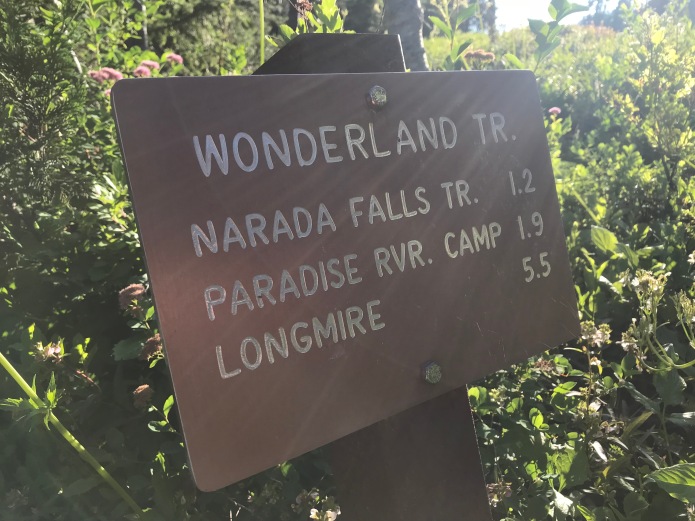
Day 1: Longmire to Mowich Lake
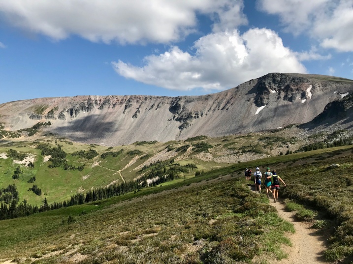
We had reserved a site at Cougar Rock Campground for the night before, and we were all settled by about 9:30 or 10. The next morning (our first day on the trail) our amazing crew for day one—Ana, Adam, and Sharon—had water boiling at 4:45 a.m. and we were packed and ready to go by 5:45 a.m. They drove us to Longmire and we took all the obligatory group photos, and then we were off. The trail starts rather anticlimactically by running along the road for a bit, and then starts heading up Rampart Ridge (and ironically taking us right by Cougar Rock campground). Our first views of the Mountain came as we crossed the Kautz Creek at about 3.5 miles.


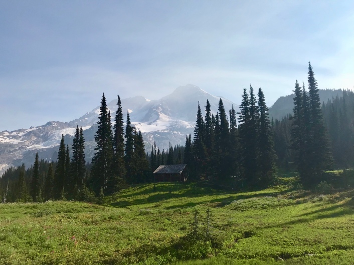
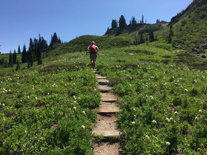
After crossing Kautz Creek, we continued our way up. This section is mostly forested and a bit of a grind. Our first landmark, at 5.5 miles and 2500 feet, was Devil’s Dream. If you think about it, that would translate to “Nightmare” and it was indeed a nightmare of bugs. We pushed into a run to get out of there and soon arrived at Indian Henry’s Hunting Ground. Oh! My! Goodness! Flower-coated meadow. Mountain views. Cabin tucked into the woods beside the meadow. It was insanely gorgeous!
From here, we had about 11 miles and 3400 feet of gain to get to our next major landmark: Klapatche Park. It was getting pretty hot by now, and we were careful to hydrate, maintain electrolytes (Nuun, Tailwind, and S-Caps were our friends on this trip), and slow down a bit to keep things under control.
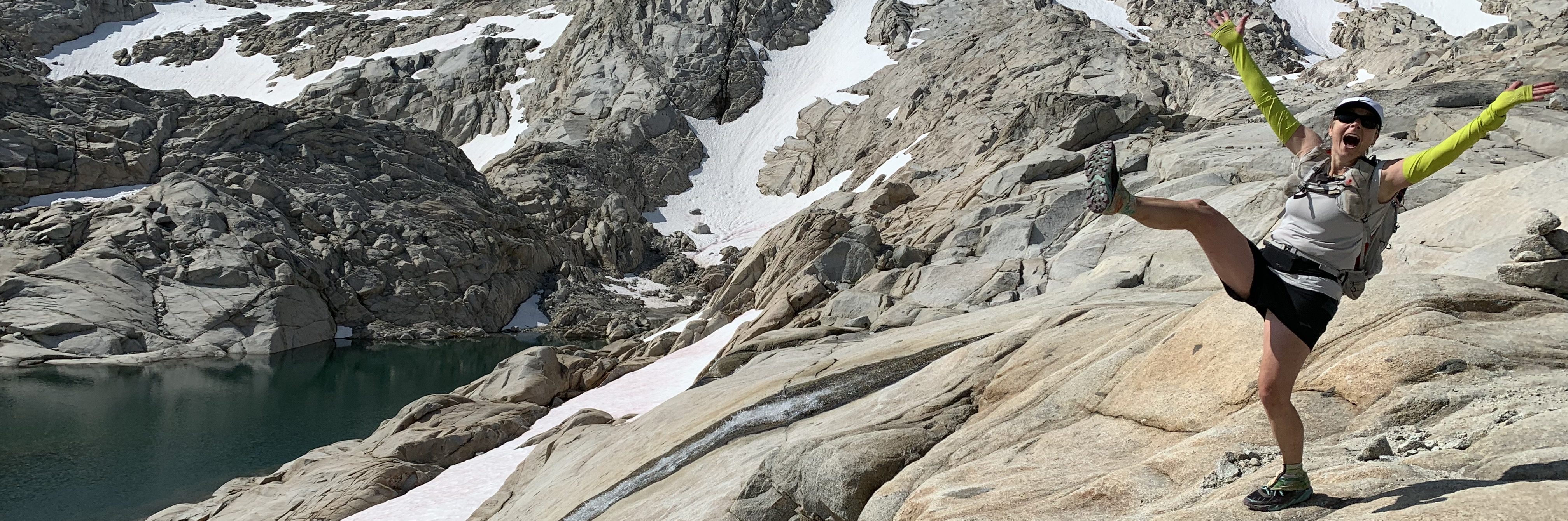
We first headed up to Emerald Ridge, which was breathtaking! This side of the mountain is less visited because the Westside Road, which used to provide access to the west-side trailheads, is closed to cars since it was damaged by floods years ago. However, you can still get there by bike, and I think it’d be a worthwhile day trip to ride up to the South Puyallup Trail and hike up to Emerald Ridge. I really liked this area: it’s alpine-y, with huge views of glaciers, moraines, and waterfalls, and the area was awash in color from magenta and orange paintbrush and dozens of other flowers that I don’t know the names of. There was even a resident marmot who ignored us as he stood on his haunches, pulled on a flower stem, and then devoured the flower. He was quite plump and cute!


A steep and rocky trail took us the mile and a half from the top of Emerald Ridge to the South Puyallup River and a stunning suspension bridge. Crossing the bridge was a thrill, and we all acted like children squealing and laughing as we bounced our way across one at a time.


Once across, we had a long hot climb up to St. Andrews Lake. The trail was often overgrown, which just seems to add a bit of misery when you’re already hot and sweaty. This was just one of several overgrown sections on day one.

At St. Andrews Lake, we encountered a family of four (the kids were 6 and 8). We were all in awe of the parents, as none of us with kids could imagine ours being out there doing what they were doing. That family and another couple were swimming and cooling off in the lake, and we quickly joined them. After the heat of the day and the long climb, the cool mountain lake water … simply utter and complete bliss!
None of us wanted to leave, but all of us wanted to get to Mowich at some point that evening, so we resigned ourselves to putting back on our shoes and packs and heading out. This next sections don’t really stand out in my mind for anything except that we kept going up and down, through the trees and out in the open. It’s about 8 miles, with 1500 feet gain and 2100 loss, to Golden Lakes, our next major landmark. The bugs seemed happy, though.
At Golden Lakes, I split off from Wendy and Heidi—with whom I’d spent the last couple of hours—and set off downhill toward the Mowich River, trying to catch up with the rest of the group. I finally caught them after a couple of miles and enjoyed their spontaneous rap songs (with Skat Master Sarah as DJ) and silliness.
My husband had hiked down to the Mowich a couple of weeks earlier to check out the crossings there. When our friend, Marna, did the Wonderland last year, the Mowich bridge was out and it made for a sketchy crossing. Mike found a bridge on the North Mowich, but the South Mowich had to be forded. So, when we got there, we decided to wait for the group to be whole again so we could be assured of everyone’s safety. As it ended up, both forks of the river are safely bridged now and it was an easy crossing.
As the sunlight waned, we worked our way up our final 2,000 foot climb over 3ish miles. I switched my headlamp on with just over a mile to go. Mike—who had arrived earlier in the day to set up camp—was waiting at the intersection with the trail that heads off (the wrong direction) to Spray Park and offered us all a bit of a scare (since it had been so long since we’d seen anyone else) as well as a sense of welcoming, and Sharon waited just up the trail and offered a warm hug and congratulations as we headed into camp.
Adam, Ana, Sharon, Heidi’s husband Bill, and Mike had hot food and cold drinks ready for us, and I don’t think we showed any manners at all as we shoveled it into our faces. (Thank you to my mother-in-law, Nancy, who’d made my favorite chili chicken with rice. It was delicious!) With our tents and sleeping bags waiting for us, we changed out some gear in our packs and fell into bed.
Day 2: Mowich Lake to White River Campground
Up again at 5 a.m., we were slower at getting ready and finally left camp at 6:30 a.m. I was excited about day two: I knew most of the trail, loved the views, and knew that it would be a shorter, easier day that ended in burgers at Sunrise Visitor Center. Translation: I was cocky, didn’t take the day as seriously as I had the day before, and I just about trashed the trip for myself as a result.
The day started with a long descent down a stunning canyon to Ipset Creek and ultimately the Carbon River. It was along this descent that Heidi stepped on a loose rock the wrong way and was suddenly sliding off the trail. Those things always happen so quickly, and luckily she slid into a tree which stopped her downhill progress. It was a good reminder that things can and do happen on the trails!

Once we hit the Carbon River, we were on known territory for me. A few years ago, Mike and I rode our mountain bikes up the Carbon River Road to Ipset Creek Campground and then hiked up to the snout of the Carbon Glacier. It was fun to revisit those memories as I ascended the same way. Once we passed Mike and my previous turnaround point, we were back again in unknown territory until we reach Old Desolate above Mystic Lake.
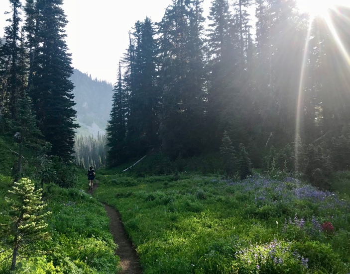
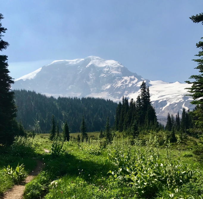
Eager to make progress on this shorter day (I really really wanted to get into camp early and take a nap!), I charged ahead, ignoring my watch chimes that I have programmed to remind me to eat, drink, and take electrolytes routinely. This section ascends just under 2000 feet over 3ish miles, and it becomes another one of those breathtakingly beautiful places along the Wonderland Trail. Without a doubt, Moraine Park—with Moraine Creek, wildflowers, and incredible views of the Mountain—was a highlight.
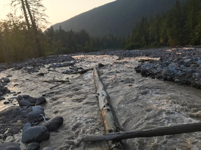
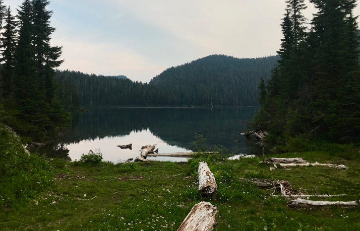
At Mystic Lake, we all needed to refill our water and then we were off again. We had been hearing from backpackers going the opposite direction that the crossing at the Winthrop Creek was bad and that we should get there as early as possible. We also heard that a man had been washed off the log bridge the day before and had died. His teenaged son had run for help, and that morning helicopters had been out searching for the body. This news definitely affected our outlooks. This was the second person to die in a river crossing in the past five days (there would be one more we’d learn about later), and we were definitely concerned.
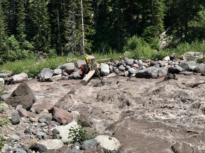
Over the 2 miles from Mystic to the Winthrop, we powered on … hoping we would arrive before the day’s warmth increased the river’s levels too much. But when we got there, we not only found the river pouring over parts of the bridge in waves, we also encountered a ranger who strongly advised against crossing. While we debated our course of action and looked at the bridge, we literally watched the water level rise. The water was so forceful that we could hear boulders rolling underwater. It seemed possible that we would have to turn back and give up on our trip. There was a work crew on the other side of the river, and they were there to install a railing to make the crossing safer. However, it would be a wait before they could complete the work. The ranger advised to wait an hour, and we could see where things stood with the bridge improvements.
As we waited, the day continued to warm and my earlier “Sunrise-or-bust” attitude started to tear me apart. I grew hotter and I started not to feel well. There are so many things I could have done during this hour, and in retrospect they’re obvious (hydrate, eat, find shade and a cooler place). But, I was frustrated about the bridge situation, I was a little scared, and I just wanted to keep going. In other words, I wasn’t thinking well.
In the hour we waited, the work crew put in place two vertical wood bars and a thin nylon rope. At this point, they said that we could make our own decision about whether to cross, but it was an adult decision that would be made by informed adults. They said they would give us each a life vest from their gear, but that the thin nylon rope and the life vest were no guarantees of our safety: the rope would probably break if we fell and our heads would probably be bashed by rocks before the vests could save us. Cheery thoughts.
After some discussion, most of us felt confident about going, but not everyone. The rangers told us we could wait another 3 hours for them to finish the bridge in order to be safer. Another group conference later, we remained split and agreed those of us who were ready to cross would, and if the remaining group members weren’t comfortable they’d wait the 3 hours and cross later.
Ultimately, all of us crossed. It was unnerving—because the water was so brown from the silt is was carrying, when the waves of water crossed the bridge I’d lose sight of my feet and the bridge itself. However, I didn’t feel any force from the water and it was actually a relatively easy crossing. My thoughts remain with the man who died and especially with his son, who witnessed everything. The mountains are serious business.
After the Winthrop, you traverse gently up and down to Granite Creek and then ascend several hundred feet through forest. Topping out affords views of Skyscraper Mountain, Mount Fremont, the valleys down to Grand Park, and the Burroughs. There are no words.

After the climb, everything caught up with me. I walked the rest of the way to Sunrise, trailing behind the group. Vivian kept an eye on me, and cheerfully announced each new spectacular view. I responded with a miserable, “I don’t care.” Just as we arrived at the parking lot of Sunrise Visitor Center, my stomach called BS and I puked up the little that was left in my stomach into the bushes. I then ran to the bathroom to take care of the other side of things. Ugh. From there, I dragged into the Visitor Center and promptly inhaled a hamburger, two bags of popcorn, and two sodas.
From Sunrise to White River is 3 downhill miles. They were some of the longest, most demoralizing miles of my life. I was frustrated with myself for mistakes over the day. My right IT band was tight and my knee hated every step. My feet were hot and sore and felt blistered. It was clear to me that my trip was up. There was no way I was going to be able to continue the next day.
At camp Wendy and I conferred. She was suffering from a swollen foot and blistering, and had realized during those same long 3 miles that her trip was up. I shared my own situation, and I think we both were in the same state of mind.
I went to bed resigned to failure. Mike encouraged me to make the call the next morning, and see how I felt after a night’s sleep. I took some Advil and drank a bottle of water. I then slept like the dead until I woke up at 4 a.m. to go to the bathroom. Then I drank another bottle of water and went back to sleep. When my alarm rang at 5 a.m., I drank another bottle of water.
Day 3: White River to Longmire
The night before, our friends Elly, Angel, and Tim had arrived to replace Ana and Adam and supplement Sharon, Mike, and Bill as crew, cheer, and support. Our friends are the best!
After that bottle of water at 5 a.m., I decided to give the last leg of the trip a try. I dressed, forced down food and changed out my day three food bag to include a quart-sized baggy of chips. I also ate a bunch of chips. Clearly salt was still high on the body-needs-this list. I talked to Wendy, who was limping through camp in her flip-flops, and I felt terribly for her. As for me, I left camp queasy, uncertain, and determined.
Our day started with crossing the White River just outside camp. Here, the river had carved a new channel the day before, and we had to rock hop and finally just walk through the water to get to the bridge over the main channel. This bridge also was partly submerged, so feet that had made it across the first channel dry now got to get wet anyway. This was a big deal because our feet were feeling the miles and keeping them happy was a priority. Oh well.
Our first destination would be Summerland, a long-time favorite of mine. Basically, everything between Summerland and Indian Bar are part of what I consider heaven on earth—beautiful meadows, high alpine ecosystems, stellar views of the Mountain! Elly, Angel, and Tim quickly caught up with us, and it made for cheery conversation to catch up with them.


At Panhandle Gap—the highest point on the Wonderland at 6800 feet—we toasted with a few sips of whisky. Angel, Tim, and Elly headed back down toward Summerland and their cars, and we headed onward.
The first time I did the climb out of Indian Bar, it kicked my butt. I was totally demoralized by this “uphill-downhill” which noodles along a ridge and provides way too many false summits. Since then, I always know what I’m in for, and I warned everyone else in advance. About halfway through the climb, we bumped into another woman, Rachel, who was also doing the Wonderland in three days, but she was solo on her trek. We invited her to join us, but she cheerfully shook her head and later passed us at a nice clip. Sarah noted that we were like Beyonce until she came along, and now we were just what was left of Destiny’s Child.
We finally hit the descent to Nickel’s Creek, and moaned about our feet as we worked our way downhill. I asked if anyone would mind stopping at the creek so I could soak my feet in the cold water, and everyone was onboard with that idea! When we arrived, Rachel was soaking her feet in the creek and she shared that two humongous blisters were troubling her. She also shared that she was the first person the teenaged boy had found after his father was swept into Winthrop Creek, and that it continued to weigh heavily on her mind. This time when we invited her to join us, she jumped at the offer, and we were once again a group of seven.
At Box Canyon, we marveled at all the people and cars and used flush toilets and washed our hands with soap and water. I love how luxuries and civilization are a shock after just a couple of days on the trail. We then headed off toward our last climb of the trip. We’d descend to the bottom of Stevens Canyon and then ascend to Reflection Lakes near Paradise. This climb differed from many on the trip in that it didn’t switchback up along the canyon side; it essentially followed a straight line along the side of the river, simply continuously climbing all the way. At one point, it crosses a creek and then ascend an evil set of stairs. Perhaps two-thirds of the way up out of the canyon, there’s a wash out that makes for a bit of a spicy eighth of a mile.

We popped out on the road and felt a sense of dislocation with the sudden change of scenery, but quickly returned to the forest for more climbing. And then suddenly we were at Louise Lake! Our climbing was essentially done!

In another half mile, we arrived at Reflection Lakes. There, Elly was waiting to accompany us the final 5 miles back to Longmire. She gave each of us a wonderful hug, and seriously it was like a smile in my soul!


The final descent along the Paradise River is a treat. The trail is relatively smooth, it’s not too steep, it’s all downhill, and it’s the homestretch. I ran most of this on my own … behind Elly, Kari, Sarah, Heidi, and Kelli and ahead of Vivian and Rachel. My feet were screaming at me, causing me to occasionally stop and flex them and breathe, but I felt strong. I—and the others—had been very attentive to our hydration, food, and electrolytes all day and it had paid off. In fact, I don’t think any of us have peed during a day on the trails as much as we had that day.
This final solo stretch was an important time for me. I spent a lot of that time reflecting on the journey, on what I had learned about myself and about my friends, on what I could do to be a better group member and person, on the giving and supportive friends and spouses who contributed to our trip, to our friends who did not start or could not finish, to my children who waited at home for me. I wish I had some definitive, trademarkable bit of wisdom to share, but I don’t. I simply know that I am blessed. My trip would never have happened if it were just me out there, alone and without purpose. My family, my husband, and my friends give me purpose and direction, and I love them. I can only strive to give back to them as they give to me.
The Wonderland Trail: Wrap-Up
When I was in my 20s, I went on two backpacking trips with my brother, Rob, and his friend, Kip, in the High Sierras of California. After those trips, I learned of the Wonderland Trail and tried to talk them into doing it with me. It’s been so long that I don’t remember why that trip never came together. But it was always there, in the back of my mind.
In recent years, I’ve covered the section along the Carbon River to the Carbon Glacier, the section between Frying Pan Creek Trailhead and Box Canyon five times, and the section from Sunrise to Mystic Lake. Each time, I’ve wanted to see more, experience more, of this wonder: a trail that goes around Mt. Rainier, that shows off its volcanic nature as well as its meadows and forests and glaciers. A trail that would challenge me mentally and physically. A trail that would overwhelm my senses with its grandeur. A trail that could be cruel and giving. I found it all.
Thank Yous
The people you do things with flavor your experiences. The right people enhance the experience and make each moment bigger, better, and simply more fun. And some people give of themselves to be your crew, to help make it happen for you. You guys are all the BEST!
Crew
- Mike Maude
- Ana and Adam Hinz
- Bill Flora
- Sharon Hendricks
Runners
- Kari Vigerstol
- Heidi Flora
- Kelli Taylor
- Sarah Brouwer
- Wendy Abbey
- Vivian Doorn
Planners, Beta Givers, and Cheer Givers
- Meredith Wells
- Marna Kagele
- Elly Searle
- Angel and Tim Mathis


All photos copyright Sarah Brouwer and me. All text copyright me. Love to all!

Such an amazing accomplishment! Thanks for sharing….on my bucket list for sure…..
LikeLike
Yes! It’s amazing! If you need any trail beta, feel free to reach out. There’s also a “Wonderland Trail” page on FB with lots of ongoing discussion, tips, trail reports, etc. to help you prepare.
LikeLiked by 1 person
Thanks so much!!!! A bucket list adventure for sure!!
LikeLike